Topographical Mapping Services
At iLand Survey Services, we provide comprehensive topographical surveys for construction and development planning, delivering precise elevation data and detailed terrain mapping that supports informed design decisions and project success.
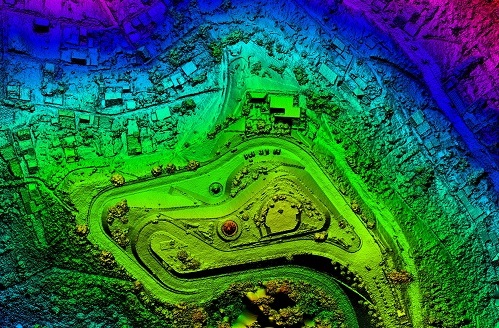
Our topographical mapping services capture detailed terrain information including contours, elevations, natural features, and existing structures to support construction planning and development projects. We specialize in creating accurate topographical maps that reveal site conditions, drainage patterns, and slope analysis essential for architectural design, engineering planning, and environmental assessment. Our comprehensive approach ensures that developers and engineers have reliable terrain data for optimal project design and construction management.
- Contour Mapping Services
- Elevation Data Collection
- Terrain Feature Mapping
- Drainage Pattern Analysis
- 3D Terrain Modeling
- Volume Calculation Reports
Our experienced surveyors utilize advanced total stations, GPS systems, and drone technology to capture comprehensive terrain data with exceptional accuracy. We deliver detailed topographical maps in various formats that support site planning, grading design, and infrastructure development while meeting industry standards for construction and engineering applications.
Frequently Asked Questions
Our topographical mapping services provide essential terrain information for successful construction and development projects. We address common site planning concerns with detailed elevation data and comprehensive terrain analysis for informed project decisions.